How can we, humans, look at our relationship to nature differently? In season three of Going Wild, on top of stories about animals, we invite you to journey through the entire ecological web — from the tiniest of life forms to apex predators — alongside the scientists, activists and adventurers who study it. Wildlife biologist and host Dr. Rae Wynn-Grant has been studying wild animals in their natural habitats all over the world for years. Our award-winning podcast takes you inside the hidde ...
…
continue reading
Content provided by Richard I. Gibson. All podcast content including episodes, graphics, and podcast descriptions are uploaded and provided directly by Richard I. Gibson or their podcast platform partner. If you believe someone is using your copyrighted work without your permission, you can follow the process outlined here https://player.fm/legal.
Similar to History of the Earth
Get in-depth coverage of current and future trends in technology, and how they are shaping business, entertainment, communications, science, politics, and society.
…
continue reading
DNA science. Artificial intelligence. Smartphones and 3D printers. Science and technology have transformed the world we live in. But how did we get here? It wasn’t by accident. Well, sometimes it was. It was also the result of hard work, teamwork, and competition. And incredibly surprising moments. Hosted by bestselling author Steven Johnson (“How We Got To Now”), American Innovations uses immersive scenes to tell the stories of the scientists, engineers, and ordinary people behind the great ...
…
continue reading
Embedded is the show for people who love gadgets. Making them, breaking them, and everything in between. Weekly interviews with engineers, educators, and enthusiasts. Find the show, blog, and more at embedded.fm.
…
continue reading
PT Inquest is an online journal club. Hosted by Jason Tuori, Megan Graham, and Chris Juneau, the show looks at an article every week and discusses how it applies to current physical therapy practice.
…
continue reading
Stephen Fry's 7 Deady Sins - I will take each one of the Seven Sins in turn, lay them out on the surgical table and poke, prod, pry and provoke in an attempt to try to anatomise and understand them; I hope and believe it will be, if nothing else, delicious fun and something of a change from the usual run of podcastery. Hosted on Acast. See acast.com/privacy for more information.
…
continue reading
The Science Show gives Australians unique insights into the latest scientific research and debate, from the physics of cricket to prime ministerial biorhythms.
…
continue reading
Get ready to have your spine tingling and your hairs standing on end with the Daily Paranormal Podcast hosted by Tony Brueski. This show is no joke - it's packed with real-life horror stories of ghosts, demons, haunted houses, possessions, shadow people, and all things supernatural that will leave you quivering with fear. Our listeners can't get enough of our bone-chilling tales, describing them as the "best ghost story podcast out there." Don't expect the same old cliché zombies, vampires, ...
…
continue reading
I discuss a variety of topics in both the natural and social sciences, exploring the many fascinating insights that the scientific method yields about the world around us.
…
continue reading
Artificial Intelligence has suddenly gone from the fringes of science to being everywhere. So how did we get here? And where's this all heading? In this new series of Science Friction, we're finding out.
…
continue reading
Player FM - Podcast App
Go offline with the Player FM app!
Go offline with the Player FM app!

))
Episode 388 Folds in Algeria
Manage episode 198378085 series 38982
Content provided by Richard I. Gibson. All podcast content including episodes, graphics, and podcast descriptions are uploaded and provided directly by Richard I. Gibson or their podcast platform partner. If you believe someone is using your copyrighted work without your permission, you can follow the process outlined here https://player.fm/legal.
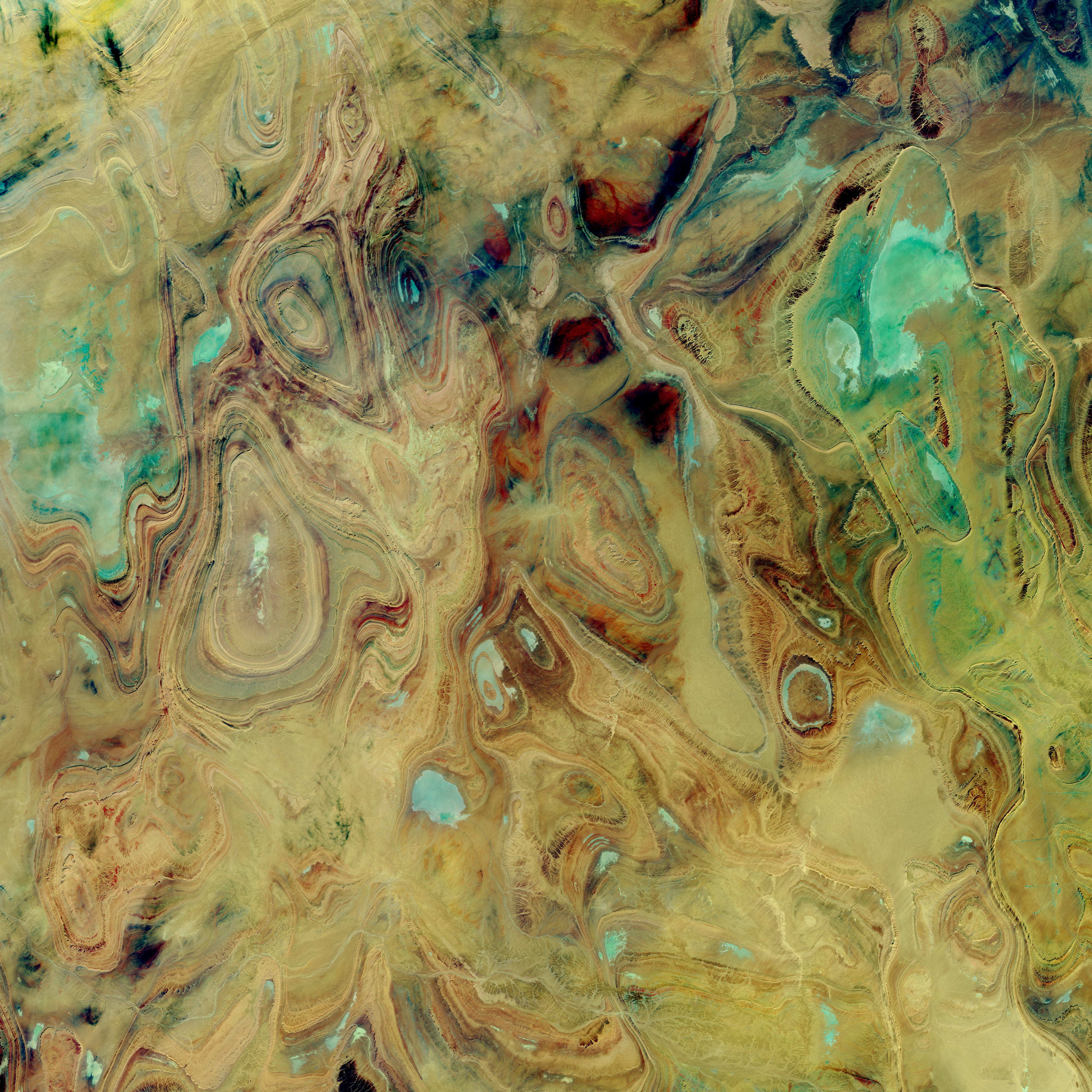
You may have seen some of the spectacular images of the earth in southern Algeria, curves and colors like some Picasso in the opposite of his cubist period. If you haven’t, check out the one from NASA, below.
The ovals and swirls, with their concentric bands, are immediately obvious to a geologist as patterns of folds, but not just linear folds like many anticlines and synclines form. These closed ovals represent domes and basins – imagine a large scale warping, both up and down, in a thick succession of diverse sedimentary rocks, like sets of nested bowls, some of them right-side up and some inverted, then all sliced off halfway through.
But “obvious to a geologist” has plenty of limitations in a space image. Without knowing more information, it’s difficult to be sure if an oval is a basin or a dome. And you can speculate, but without some ground truth, it’s challenging to be sure what the rock types are.
This area, called the Ahnet-Mouydir, on the flank of the Hoggar Mountains close to the middle of the Sahara Desert, is remote, inhospitable, and arid, and called the “land of terror” for a reason. The rocks represent a thick sequence of marine sandstones, shales, and limestones, spanning a huge range of ages, from at least the Ordovician to the early Carboniferous – 150 million years or more, a great chunk of the Paleozoic era.
 |
| Ahnet-Mouydir, Hoggar Mountains, Algeria. NASA image - source |
This area, called the Ahnet-Mouydir, on the flank of the Hoggar Mountains close to the middle of the Sahara Desert, is remote, inhospitable, and arid, and called the “land of terror” for a reason. The rocks represent a thick sequence of marine sandstones, shales, and limestones, spanning a huge range of ages, from at least the Ordovician to the early Carboniferous – 150 million years or more, a great chunk of the Paleozoic era.
The core of the Hoggar Mountains is an old Precambrian block, not as big as the cratons and shields that form the hearts of most of the continents, but otherwise similar. It might have been something like a microcontinent that became amalgamated into the growing supercontinent of Gondwana about 600 million years ago. After that amalgamation, seas came and went much like they did in western North America throughout much of the Paleozoic era, laying down the sediments that became the rocks we see today in the northern Hoggar Mountains.
That’s all well and good – but here’s the next question, how did the rocks get deformed into these oval domes and basins? If you imagine the kinds of collisions that are typical on earth, you think of linear or curvilinear things – island arcs, edges of continents and such – that when they collide, are likely to make linear belts of deformation. This is why so many mountain ranges are long, linear features, and the folds and faults that make them up also tend to be linear. Domes and basins happen, but that seems to be almost all we have here in these mountains.
We have to look for a deformational event that is later than the youngest rocks deformed. So if some of these rocks are as young as early Carboniferous, about 340 million years old, the mountain-building event that fills the bill is the Hercynian Orogeny, where ‘orogeny’ just means mountain-building.
The Hercynian, at about 350 to 280 million years ago, represents the complex collision between Gondwana and the combined North America and Europe, which were already more or less attached to each other. The leading edge of Gondwana that collided was in what is now North and West Africa, and the collision produced mountain ranges all over – the Alleghenies in the central Appalachians in North America, and a complex swath of mountains across central Europe, from Spain, across France to northern Germany and into Poland, as well as elsewhere. In Africa, the most intense squeezing was at the leading edge, in what is now Morocco and Mauritania, colliding with North America, and northern Algeria, impacting Iberia.
The basins and domes of southern Algeria that we’re trying to understand are 1500 kilometers or more from that leading edge of continental collision. So I think – and full disclosure, I’ve never really researched this area in detail – that what must have happened is that that distant hinterland wasn’t pushed into tight, linear belts like those we find along the lines of collision, but the force was enough to warp the sediments into these relatively small domes and basins. Alternatively, it might be possible that the brittle Precambrian rocks beneath the sedimentary layers broke from the force of the collision, so that the sedimentary layers draped over the deeper brittle surface like a carpet lying over a jumble of toy building blocks – some high, some low.
The latter idea, that the brittle basement rocks were broken and pushed upward with the sedimentary layers draped over them is supported by research published in the journal Terra Nova in 2001. Hamid Haddoum and colleagues studied the orientations of folds and faults in this area, trying to figure out the orientations of the stresses that caused them. Their data show a shortening direction – which means compression, or squeezing – during early Permian time oriented about northeast-southwest. That is consistent with the collision that was happening at that same time between what is now Senegal and Mauritania, in westernmost Africa, and the Virginia-Carolinas region of what is now the United States. Haddoum and his colleagues show cross-sections with basement upthrusts, basically high-angle reverse faults where older rocks are squeezed so much that they are pushed up and over younger rocks. This is quite similar to the Laramide Orogeny in the western United States about 80 to 50 million years ago, but this compression was happening about 280 million years ago as the supercontinent of Pangaea was assembled during the early Permian Period. Both represent deformation at relatively great distances from the lines of continental collision. In the case of the Laramide in western United States, one idea for transmitting the stress so far from the collision is that the subducting slab of oceanic crust began to go down at a relatively gentle angle, even close to horizontal, creating friction and stress further away from the subduction zone than normal. Whether that’s the case here in southern Algeria isn’t clear for this Hercynian collision.
I wouldn’t think of this area as high mountains, such as those that must have formed along the lines of Hercynian collision. Maybe more like warped, uplifted plateaus – but whatever they were, they were certainly subject to erosion. Erosion probably wore the domes and basins down to a common level, so that the nested bowls were exposed in horizontal cross-section – which for geologists is the equivalent of a geologic map. And that’s what the beautiful photos reveal.
The area might have been planed off even more by Permian glaciers during and after the Hercynian mountain-building events. But then, during the Mesozoic era, seas returned to the region and all this mess of eroded domes and basins was buried beneath even more sediments. Sometime relatively recently, during the Cenozoic era, the past 65 million years, everything was uplifted at least gently, so that the highest parts – including today’s Hoggar Mountains, were stripped of the younger Mesozoic sedimentary rocks, revealing the much older Paleozoic rocks in the domes and basins.
—Richard I. Gibson
Link:
50 episodes
Manage episode 198378085 series 38982
Content provided by Richard I. Gibson. All podcast content including episodes, graphics, and podcast descriptions are uploaded and provided directly by Richard I. Gibson or their podcast platform partner. If you believe someone is using your copyrighted work without your permission, you can follow the process outlined here https://player.fm/legal.
You may have seen some of the spectacular images of the earth in southern Algeria, curves and colors like some Picasso in the opposite of his cubist period. If you haven’t, check out the one from NASA, below.
The ovals and swirls, with their concentric bands, are immediately obvious to a geologist as patterns of folds, but not just linear folds like many anticlines and synclines form. These closed ovals represent domes and basins – imagine a large scale warping, both up and down, in a thick succession of diverse sedimentary rocks, like sets of nested bowls, some of them right-side up and some inverted, then all sliced off halfway through.
But “obvious to a geologist” has plenty of limitations in a space image. Without knowing more information, it’s difficult to be sure if an oval is a basin or a dome. And you can speculate, but without some ground truth, it’s challenging to be sure what the rock types are.
This area, called the Ahnet-Mouydir, on the flank of the Hoggar Mountains close to the middle of the Sahara Desert, is remote, inhospitable, and arid, and called the “land of terror” for a reason. The rocks represent a thick sequence of marine sandstones, shales, and limestones, spanning a huge range of ages, from at least the Ordovician to the early Carboniferous – 150 million years or more, a great chunk of the Paleozoic era.
|
| Ahnet-Mouydir, Hoggar Mountains, Algeria. NASA image - source |
This area, called the Ahnet-Mouydir, on the flank of the Hoggar Mountains close to the middle of the Sahara Desert, is remote, inhospitable, and arid, and called the “land of terror” for a reason. The rocks represent a thick sequence of marine sandstones, shales, and limestones, spanning a huge range of ages, from at least the Ordovician to the early Carboniferous – 150 million years or more, a great chunk of the Paleozoic era.
The core of the Hoggar Mountains is an old Precambrian block, not as big as the cratons and shields that form the hearts of most of the continents, but otherwise similar. It might have been something like a microcontinent that became amalgamated into the growing supercontinent of Gondwana about 600 million years ago. After that amalgamation, seas came and went much like they did in western North America throughout much of the Paleozoic era, laying down the sediments that became the rocks we see today in the northern Hoggar Mountains.
That’s all well and good – but here’s the next question, how did the rocks get deformed into these oval domes and basins? If you imagine the kinds of collisions that are typical on earth, you think of linear or curvilinear things – island arcs, edges of continents and such – that when they collide, are likely to make linear belts of deformation. This is why so many mountain ranges are long, linear features, and the folds and faults that make them up also tend to be linear. Domes and basins happen, but that seems to be almost all we have here in these mountains.
We have to look for a deformational event that is later than the youngest rocks deformed. So if some of these rocks are as young as early Carboniferous, about 340 million years old, the mountain-building event that fills the bill is the Hercynian Orogeny, where ‘orogeny’ just means mountain-building.
The Hercynian, at about 350 to 280 million years ago, represents the complex collision between Gondwana and the combined North America and Europe, which were already more or less attached to each other. The leading edge of Gondwana that collided was in what is now North and West Africa, and the collision produced mountain ranges all over – the Alleghenies in the central Appalachians in North America, and a complex swath of mountains across central Europe, from Spain, across France to northern Germany and into Poland, as well as elsewhere. In Africa, the most intense squeezing was at the leading edge, in what is now Morocco and Mauritania, colliding with North America, and northern Algeria, impacting Iberia.
The basins and domes of southern Algeria that we’re trying to understand are 1500 kilometers or more from that leading edge of continental collision. So I think – and full disclosure, I’ve never really researched this area in detail – that what must have happened is that that distant hinterland wasn’t pushed into tight, linear belts like those we find along the lines of collision, but the force was enough to warp the sediments into these relatively small domes and basins. Alternatively, it might be possible that the brittle Precambrian rocks beneath the sedimentary layers broke from the force of the collision, so that the sedimentary layers draped over the deeper brittle surface like a carpet lying over a jumble of toy building blocks – some high, some low.
The latter idea, that the brittle basement rocks were broken and pushed upward with the sedimentary layers draped over them is supported by research published in the journal Terra Nova in 2001. Hamid Haddoum and colleagues studied the orientations of folds and faults in this area, trying to figure out the orientations of the stresses that caused them. Their data show a shortening direction – which means compression, or squeezing – during early Permian time oriented about northeast-southwest. That is consistent with the collision that was happening at that same time between what is now Senegal and Mauritania, in westernmost Africa, and the Virginia-Carolinas region of what is now the United States. Haddoum and his colleagues show cross-sections with basement upthrusts, basically high-angle reverse faults where older rocks are squeezed so much that they are pushed up and over younger rocks. This is quite similar to the Laramide Orogeny in the western United States about 80 to 50 million years ago, but this compression was happening about 280 million years ago as the supercontinent of Pangaea was assembled during the early Permian Period. Both represent deformation at relatively great distances from the lines of continental collision. In the case of the Laramide in western United States, one idea for transmitting the stress so far from the collision is that the subducting slab of oceanic crust began to go down at a relatively gentle angle, even close to horizontal, creating friction and stress further away from the subduction zone than normal. Whether that’s the case here in southern Algeria isn’t clear for this Hercynian collision.
I wouldn’t think of this area as high mountains, such as those that must have formed along the lines of Hercynian collision. Maybe more like warped, uplifted plateaus – but whatever they were, they were certainly subject to erosion. Erosion probably wore the domes and basins down to a common level, so that the nested bowls were exposed in horizontal cross-section – which for geologists is the equivalent of a geologic map. And that’s what the beautiful photos reveal.
The area might have been planed off even more by Permian glaciers during and after the Hercynian mountain-building events. But then, during the Mesozoic era, seas returned to the region and all this mess of eroded domes and basins was buried beneath even more sediments. Sometime relatively recently, during the Cenozoic era, the past 65 million years, everything was uplifted at least gently, so that the highest parts – including today’s Hoggar Mountains, were stripped of the younger Mesozoic sedimentary rocks, revealing the much older Paleozoic rocks in the domes and basins.
—Richard I. Gibson
Link:
50 episodes
All episodes
×Welcome to Player FM!
Player FM is scanning the web for high-quality podcasts for you to enjoy right now. It's the best podcast app and works on Android, iPhone, and the web. Signup to sync subscriptions across devices.
Similar to History of the Earth
How can we, humans, look at our relationship to nature differently? In season three of Going Wild, on top of stories about animals, we invite you to journey through the entire ecological web — from the tiniest of life forms to apex predators — alongside the scientists, activists and adventurers who study it. Wildlife biologist and host Dr. Rae Wynn-Grant has been studying wild animals in their natural habitats all over the world for years. Our award-winning podcast takes you inside the hidde ...
…
continue reading
Get in-depth coverage of current and future trends in technology, and how they are shaping business, entertainment, communications, science, politics, and society.
…
continue reading
DNA science. Artificial intelligence. Smartphones and 3D printers. Science and technology have transformed the world we live in. But how did we get here? It wasn’t by accident. Well, sometimes it was. It was also the result of hard work, teamwork, and competition. And incredibly surprising moments. Hosted by bestselling author Steven Johnson (“How We Got To Now”), American Innovations uses immersive scenes to tell the stories of the scientists, engineers, and ordinary people behind the great ...
…
continue reading
Embedded is the show for people who love gadgets. Making them, breaking them, and everything in between. Weekly interviews with engineers, educators, and enthusiasts. Find the show, blog, and more at embedded.fm.
…
continue reading
PT Inquest is an online journal club. Hosted by Jason Tuori, Megan Graham, and Chris Juneau, the show looks at an article every week and discusses how it applies to current physical therapy practice.
…
continue reading
Stephen Fry's 7 Deady Sins - I will take each one of the Seven Sins in turn, lay them out on the surgical table and poke, prod, pry and provoke in an attempt to try to anatomise and understand them; I hope and believe it will be, if nothing else, delicious fun and something of a change from the usual run of podcastery. Hosted on Acast. See acast.com/privacy for more information.
…
continue reading
The Science Show gives Australians unique insights into the latest scientific research and debate, from the physics of cricket to prime ministerial biorhythms.
…
continue reading
Get ready to have your spine tingling and your hairs standing on end with the Daily Paranormal Podcast hosted by Tony Brueski. This show is no joke - it's packed with real-life horror stories of ghosts, demons, haunted houses, possessions, shadow people, and all things supernatural that will leave you quivering with fear. Our listeners can't get enough of our bone-chilling tales, describing them as the "best ghost story podcast out there." Don't expect the same old cliché zombies, vampires, ...
…
continue reading
I discuss a variety of topics in both the natural and social sciences, exploring the many fascinating insights that the scientific method yields about the world around us.
…
continue reading
Artificial Intelligence has suddenly gone from the fringes of science to being everywhere. So how did we get here? And where's this all heading? In this new series of Science Friction, we're finding out.
…
continue reading
Player FM - Podcast App
Go offline with the Player FM app!
Go offline with the Player FM app!


